 |
Established Since 1992 Why Buy From 6thplanet ? |
Laminated Office Wall map
of UK Post Code Areas
840mm 1200mm by Map Marketing
|
|
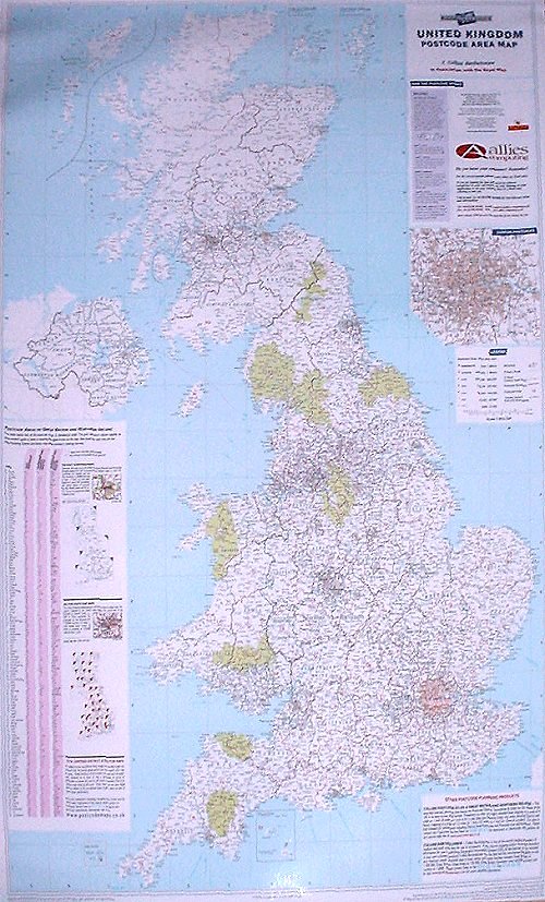
Map of UK Postcode Areas
Map of UK Postcode Areas - detail This excellent business planning map presents both the Postcode Area boundaries and the most up-to-date County and Unitary Authority boundary information for the whole UK. Clearly shown on a black-and-white base map (with national parks highlighted in pale green), the Postcode Area boundaries and their corresponding letters are displayed in red with County / Unitary Authority boundaries shown in dark green. The map base contains motorways, primary roads (plus A roads in London) and features seven types of town/city stamps based on populations ranging from 2,000 to 1,000,000 plus inhabitants. Due to the large number of Postcode Areas within metropolitan London, the map also contains a more detailed inset (1 inch to 4 miles) of the area within the M25 motorway. This map also features a handy index detailing all 124 Postcode Areas (including the name of each Areas main postal town/city) enabling users to locate rapidly an Area on the map. In addition, the map provides detailed definitions of the different levels of Postcode detail (Area, District and Sector) and how they are structured. Our Postcode Areas Map is updated and reprinted annually ensuring you receive the most current Area boundary information available. Size: 120 x 83 cm (47 x 33 inches). Scale: 1:800 000 (1 inch to 12 miles). |
|
RRP 26.99 |

| A Vat invoice will be provided with Vat Shown separately. | Ref : MapUkPostCodes |
| EAN |
Info and Billing
| Payment
Methods Debit Cards - Visa Delta, Solo, Maestro, Electron Credit Cards - Visa, MasterCard, AMEX Also Cheque with Clearance (7 to 10 Working days) |
|